Campania Climate Hub
The Campania Climate Hub is the climate service on Dataclime developed for the Campania Region to interactively explore the regional climate framework and support the planning of climate change adaptation policies and interventions. The service collects a set of climate indicators selected through co-design with regional offices, consistent with the national adaptation guidelines.
Objectives
- Understanding how the climate is changing in Campania.
- Evaluating the evolution of extreme events relevant to territories and sectors.
- Supporting analysis and technical documents with downloadable maps and data.
The service allows users to explore dynamic maps at the regional scale, consult results at the provincial and municipal scales (ISTAT base units), select indicators, periods and administrative levels, and download outputs in CSV/PNG.
All data used in this product comes from public and open access sources. In each specific section you can consult the terms of use of the different data sources used.
Complete ReportE-OBS Dataset
This section offers a comprehensive mapping of climate indicators defined under the Regional Climate Framework over the reporting period (1981-2010 and 1991-2020) using the E-OBS dataset. The maps allow us to identify the spatial trend of climate indicators up to the municipal scale, highlighting any localized critical issues. Depending on the indicator and the display scale selected, the time series (or climate strips) of anomalies from 1981 to 2024 can be displayed at the bottom compared to the reference values calculated over the reference period (1981-2010 and 1991-2020).
Filters
Model Data
E-OBS
E-OBS
Download the selected map in Zip format.
Accumulated Precipitation in wet days (PRCPTOT)
(PRCPTOT)
Daily precipitation sum in wet days (days with precipitation greater than or equal to 1 mm).
Season: Yearly
Measurement unit: mm
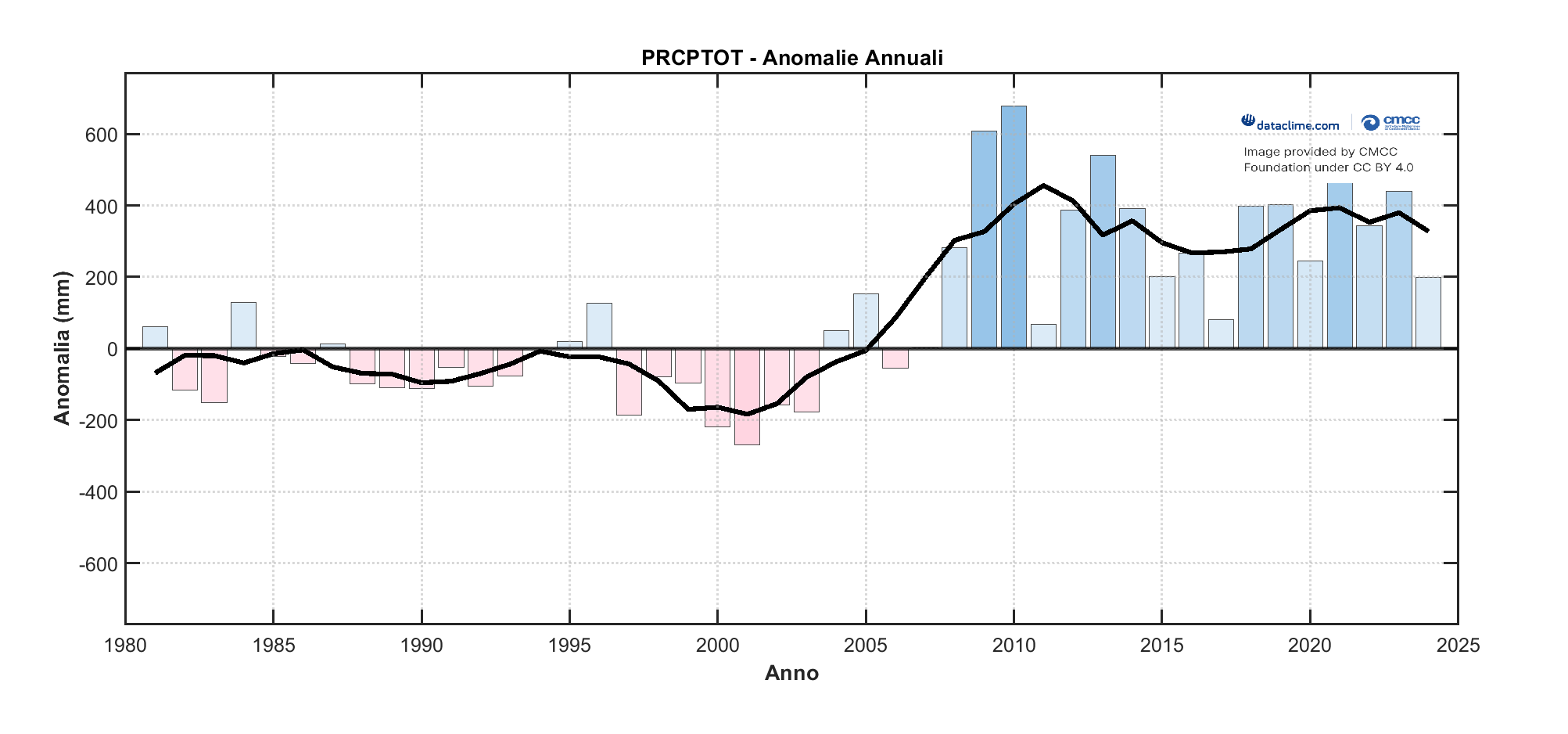
Time series of the selected indicator
The time series shows the trend of anomalies from 1981 to 2025. Anomalies represent the deviation from the baseline climatology calculated over the reference period (1981-2010 or 1991-2020). The thick black line represents the trend calculated using a 5-year moving average.
| Value | Standard deviation |
|---|---|
| 665 mm | 114 mm |
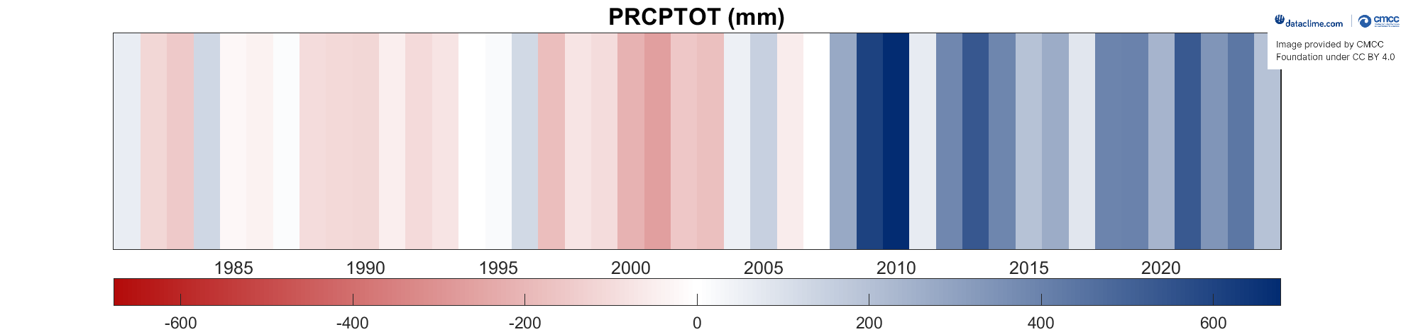
Stripes of the selected indicator
The "Climate stripe" shows the trend of annual anomalies of the selected indicator over time, from 1981 to 2025. Anomalies are calculated against a standard reference period (1981-2010 or 1991-2020). The colour variation of the stripes (on a scale from blue to red) is directly related to the intensity of the indicator’s anomaly. The stripes visually represent the deviation of each year from the thirty-year reference average.
Scarica il file Zip della mappa selezionata.
Cite Dataclime
Users are kindly requested to mention the use of Dataclime, cite the website www.dataclime.com, the CMCC Foundation and the references listed below in any publication or presentation resulting from the use of this data.
The information provided on this page was generated using the E-OBSv30 gridded dataset. E-OBS represents an observational dataset on a regular grid (land only)
available for Europe, obtained by averaging a large number of interpolation experiments on historical precipitation and temperature series.
The interpolated time series come from the European Climate Assessment & Dataset (ECA&D) project station network and are provided by national and
European services or other institutions involved in data management and storage. The dataset has daily temporal resolution and spatial resolution
in two versions, 0.25° (about 28 km) and 0.1° (about 10 km), with pan-European coverage for the time period 1950-2021.
The reliability of the dataset is generally considered valid, although it varies across Europe, due to the different coverage in terms of
meteorological stations used as input for interpolation (lower in southern Italy than in the North).
It is important to note that the CMCC Foundation and the Dataclime developers assume no responsibility for the use, interpretation, or
consequences of the data presented in any material. Users are advised to exercise due diligence in their applications and interpretations
of the data and are encouraged to consult the official documentation provided by Dataclime and the CMCC Foundation for citation and
recognition guidelines. The user assumes full responsibility, excluding any form of liability on the part of the Foundation, for any
decision taken and for any direct or indirect damage that may result from the use of the data and information contained on this site,
and will indemnify and hold the Foundation harmless from any claims that may be made, including by third parties.